
The Airfield Circuits of Great Britain & Northern Ireland
Details
Well, that's the main part of our story done, the tale has for the most part been told.
But what about the race circuits themselves? Well the next few pages will supply some more details about each of them. They will also record the actual layouts in-situ, using aerial photographs.
Of course we can never be 100% certain of the details when it comes to temporary tracks with hay bales to lay out the course, but using aerial photos, contemporary accounts, and accepted layout diagrams should allow us to get reasonably close.
So this supplement to the site will simply show some of the satellite images of the airfields themselves, whispering ghosts of those mammoth structures. Where possible, it will also record the layouts of the racing circuits using the best information from the past and present, and perhaps provide a little extra information for those who want to learn more.

The Tracks, Abingdon to Croft
Aerial photos and details of Abingdon, Bishopscourt, Boreham, Brough, Bruntingthorpe, Carnaby, Catterick, Chivenor, Crail and Croft airfields and race tracks.
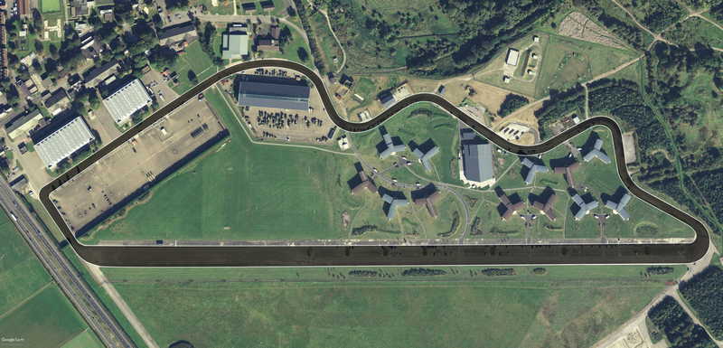
Abingdon
Abingdon, Oxfordshire | Track Length: 1.57 miles, 2.52 km | Direction: Clockwise
RAF Abingdon was opened in 1932, initially as a training station. The base was transferred to the British Army in 1992 and it was renamed Dalton Barracks. The site has hosted motor cycle racing, and is still used as both an airfield and a track day venue to the present day. Since the runways and perimeter roads are all still in use, the old race track is clearly visible, as you can see below.
Abingdon Aerial


Bishopscourt
Downpatrick, County Down | Track Length: 3.00 miles, 4.83 km | Direction: Clockwise | Track Used: 1947-Present
Built in 1943, RAF Bishopscourt was an airfield, radar control and reporting station, which closed in 1990. Its use as a race track began in 1946, and continues to this day. The layout shown here was used until 1973, then after a gap of nearly twenty years, the circuit opened again with a new 1.83 mile layout, which I haven't highlighted, but which you can see on the left, in the photos below.
Bishopscourt Aerial


Boreham
Boreham, Essex | Track Length: 3.00 miles, 4.28 km | Direction: Clockwise | Track Used: 1949-52
RAF Boreham was opened in 1944, and was used by the United States Army Air Forces as a bomber and a troop transport airfield for paratroopers. With the facility released from military control in 1946, the West Essex Car Club developed the 4.76 kilometre perimeter track for motor racing. In 1955 the Ford Motor Company bought the airfield to use as a test facility for trucks, as well as the base for their Competitions Department where they prepared their cars.
In spite of being fairly well known in its day, Boreham circuit has proved to be one of the most difficult tracks to pin down precisely. We know where it was, and we have plenty of layout diagrams, but the old airfield site was sold for quarrying in 1996, so little evidence of the exact location of the perimeter roads exists.
Fortunately there is an old R.A.F. aerial photo of the site, clearly showing the airfield, and enough of the surrounding countryside for me to superimpose the photo onto current satellite views, and place the track quite precisely.
One might presume that any placement using natural features such as hedges could be rather unreliable, but in fact their role as property boundaries make them enduring and reliable features, certainly more so than all the buildings and runways, which have all but gone. As you can see from the superimposed image below, there are at least a dozen correlations around the edges, allowing me to accurately plot the layout of the race track.
Boreham Aerial


Brough
Brough, East Riding of Yorkshire | Track Length: 1.17 miles, 1.88 km | Track Used: 1949-57
Brough is quite unusual in this collection, in so much as it was, and still is a commercially owned airfield, rather than an RAF base. Originally owned by the Blackburn Aeroplane & Motor Company, it later came under the ownership of Hawker Siddeley Aviation in the 1960s, then British Aerospace and later BAE Systems. The aerodrome was used to test seaplanes in WWI, to train fighter pilots in WWII, and later to build Harrier jump jets.
As a race track, it's main claim to fame is that it was where Stirling Moss won his first F3 race. But the actual layout of the track is a little more complicated.
One of the sources I've used throughout this section are contemporary, or accepted track layout diagrams, as they are such a good starting point. If they match up with the aerial photos, and if I can also use Google Earth to measure the lap length and match that up, then I've got three matching verifications, and can be reasonably sure that I've got an accurate and definitive layout.
The lap length might seem inconsequential, but the truth is that it's probably much more accurate than any diagram, because it could be easily measured by any car fitted with an odometer. However, without the aid of aerial photos track diagrams can be quite misleading. Brough is a case in point. Unless the aerodrome has been substantially altered, without any remaining evidence of the past configuration, then the roughly drawn track diagram that is generally available, looks inaccurate. In this case, in the absence of other evidence, I've had to go with the physical evidence of the aerial photographs.
Brough Aerial


Bruntingthorpe
Lutterworth, Leicestershire | Track Length: 4.20 miles, 6.76 km
RAF Bruntingthorpe was decomissioned in 1962, but the site continued in use as an airfield, known as Bruntingthorpe Aerodrome, and is also still used as a proving and testing ground, and storage facility for vehicles, as well as hosting track days.
Bruntingthorpe Aerial


Carnaby
Carnaby, East Yorkshire | Track Length: 4.20 miles, 6.76 km | Direction: Clockwise | Track Used: 1975-88
There's not much left of Carnaby airfield nowadays. As you can see from the photo below, it's now fairly densely populated with industrial buildings. But you can still clearly see the outline of the huge rectangular slab of the runway, which made this airfield quite unusual.
Only three airfields were built to this configuration. They were all built along the East coast of England as emergency landing strips for stricken or damaged bombers, they were all aligned roughly East-West to help incoming pilots, and their runways were huge, at least in width. Carnaby's runway was a massive 230m wide.
What's more, Carnaby was also equipped with FIDO (Fog Investigation and Dispersal Operation). FIDO was a system which involved pumping hundreds of thousands of gallons of petrol per hour along pipes set either side of the runway. The fuel was then ignited through burner jets, and this was supposed to clear the fog directly over the runway. Amazingly this seems to have worked.
Although it's not famous, and in spite of there being few remains of the old airfield, and even less of the race track, I think Carnaby airfield is worth a second look, and possibly even a salute, because more than 1,400 bombers made an emergency landing at Carnaby in the war.
Carnaby Aerial


Tracing the route of the old circuit did not prove easy, because the track was somewhat temporarily laid out, and because the site has been so developed. But thanks to some old video and contemporary accounts, I think the layout above is fairly accurate.
Motorcycles and Sidecars at Carnaby
Castle Combe
Castle Combe, Wiltshire | Track Length: 1.85 miles, 2.98 km | Direction: Clockwise | Track Used: 1950-Present
RAF Castle Combe opened in May 1941 on land which belonged to the Castle Combe estate. It was used as a practice landing ground until it was decommissioned in 1948.
Castle Combe Circuit opened in 1950 and has since hosted a wide range of motorsports events, including BTCC, British Superbikes, Formula One (non championship), F2, F3, F5000, track days and car shows. The track was modified in 1998, with two chicanes being added in response to a number of high speed accidents.
Castle Combe Aerial


Catterick
Catterick, North Yorkshire | Track Length: 1.63 miles, 2.62 km | Track Used: 1958-63
Catterick Airfield first opened in 1914 as a Royal Flying Corps training base. It served as an RAF base until 1994, when it was transferred to the Army and became Marne Barracks. The main runways and perimeter roads remain intact, so the route of the old race circuit is still clearly visible.
Catterick Aerial

Charterhall
Greenlaw, Berwickshire | Track Length: 1.96 miles, 3.15 km | Direction: Clockwise | Track Used: 1952-64
Originally a First World War landing ground named Eccles Toft, the airfield was reconstructed in 1942 as RAF Charterhall, and was used mainly as a training airfield until it was decomissioned in 1947. As a race track Charterhall hosted Formula Two, Formula Libre and Formula Junior with drivers such as Jim Clark, Sir Jackie Stewart and Sir Stirling Moss all taking part. Much of the outline of the old airfield still remains visible, though it's condition seems much deteriorated.
Charterhall Aerial


Chivenor
Braunton, Devon | Track Length: 1.60 miles, 2.57 km
Originally a civil airfield opened in the 1930s, the site was taken over by the Royal Air Force and was operational as a Coastal Command Station between May 1940 and 1995, when it was transferred to the Royal Marines. Apart from a track diagram, details of the airfield's use as a race track are difficult to find, but the track layout is at least clear.
Chivenor Aerial


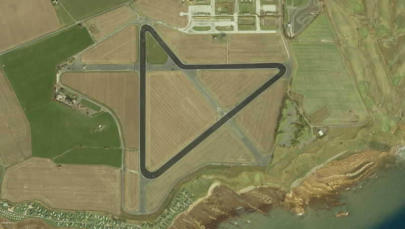
Crail
Crail, Fife | Track Length: 1.37 miles, 2.20 km
Crail is one of the best preserved Second World War airfields in Britain and the whole site has been listed. It opened briefly in July 1918, but was closed later in 1919 and laid dormant until the Second World War, when the Royal Navy commissioned the airfield as HMS Jackdaw.
Crail is still used for a number of motorsports events, including track days, 1/4 mile drag racing and club hire.
Crail Aerial

Croft
Dalton-on-Tees, County Durham | Track Length: 2.13 miles, 3.42 km | Direction: Clockwise | Track Used: 1948-present
RAF Croft was opened in 1941 for use by the RAF, but by 1942 the aerodrome had been taken over by the Royal Canadian Air Force for training. Originally named RAF Dalton-on-Tees after the nearby village, it was hastily renamed, after initial confusion with the also newly opened RAF Dalton near Thirsk, just 25 miles away. The station was closed in the summer of 1946.
The Darlington & District Motor Club began organising events for cars and motorcycles from 1948, using the majority of one of the runways and the perimeter roads at the southern end of the aerodrome. Croft Circuit is now a regular venue for the British Touring Car Championship, with the summer round being the largest event held at the circuit. British GT and F3 also visited for a number of years, and British Superbikes also used the track until the 2011 season.
The track itself has used several different configurations over the years, and continues to offer several alternative layouts, including a rallycross track.
Croft Aerial


